|
HOME
.
TOUR & SAFARI Co's
PLACES
TO VISIT
Victoria Falls
Zambezi River
Lake Kariba
Lake Tanganyika
Other Waterfalls
Chimp Sanctuary
Shiwa Ngandu
Lake Bangweulu
Livingstone Memorial
Lake Mweru
Monuments
Museums
Art Galleries
GAME
RESERVES
South Luangwa
North Luangwa
Lower Zambezi
Kafue
Sumbu
Lochinvar
Nyika
Sioma Ngwezi
Kasanka
Bangweulu Wetlands
Liuwa Plain
Mosi-o-Tunya
Luambe
Blue Lagoon
Other Smaller Parks
CITIES
& TOWNS
Lusaka
Livingstone
The Copperbelt
Other Towns
SAFARIS
Walking
Safaris
Birding Safaris
Canoeing
Safaris
Mobile Safaris
Elephant Back Safaris
Horse Back
Safaris
Photographic
Safaris
Open
Vehicle Safaris
ADVENTURE/SPORTS
Driving around Zambia
White Water
Rafting
River Boarding
Bungi Jumping
Abseiling
Gorge Swinging
Horse Trails
Tandem Kayaking
Canoeing/River Safaris
House Boating
Tiger and Fly
Fishing
WILDLIFE
Illustrated
Checklists
BIRDLIFE
In depth synopsis
Checklists
DIRECTORY
Adventure
Companies
Airlines
Air
Charter
Art
Galleries
Backpackers
Campsites & Chalets
Car
Hire
Coaches
/ Buses
Embassies
Emergency Numbers
Fishing
Camps
Game
Lodges
Golf Courses
Private
Reserves
Govt Offices
Guesthouses
Hospitals
Hotels
Safari Operators
Tours
Trains
Travel
Agents
TRAVEL INFO
Quick
Facts
Getting
There
Getting
Around
Handy Information
Visa Info
PEOPLE
History
Culture
Major Tribes
Ceremonies
ENVIRONMENT
Geography
Vegetation
Conservation
MAPS
PHOTO GALLERIES
LINKS
TRAVEL NEWS
ENQUIRIES
ADVERTISING
|

ENVIRONMENT/GEOGRAPHY
The Land
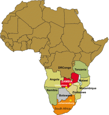
Zambia takes its name from the Zambezi
River, which rises in the north-west corner of the country and forms its
southern boundary. The landlocked country lies between latitudes 10o
and 18o South and longitudes 22o and 33o
East.
It’s neighbours are: Congo DR to the
north and north west, Tanzania to the north east, Malawi to the East,
Mozambique to the south east, Zimbabwe to the south, Botswana and
Namibia to the South west and Angola to the West.
Zambia’s
752, 000
square kilometres makes it a
large country about the size of France, the Netherlands, Belgium and
Switzerland combined. It consists for the most part of a high plateau,
with an average height of between 1060 and 1363 meters above sea
level. (3500 and 4500 ft). Isolated mountain ridges rise to more than
6000 ft with an occasional peak above 7000 ft on the eastern border,
called Nyika Plateau. Over most of the country the surface tends to be
flat, broken by small hills, the result of countless ages of undisturbed
erosion of the underlying crystalline rocks. These rocks contain the
bulk of the country’s wealth in the form of minerals and the 90 mile
long corridor known as the Copperbelt, along the north-western part of
the country, is the mainstay of the economy.

The level of the land falls southward
from the Congo DR / Zambezi divide in the north towards the Zambezi
depression in the South. The plateau is broken by the huge valleys of
the Upper Zambezi and its major tributaries, of which the Kafue and
Luangwa rivers are the largest. One result of the plateau formation of
Africa generally is the swift discharge of water towards the coast and
the interruption of the rivers by waterfalls and rapids. This has made
them of little value for transport over their length, but very suitable
for hydroelectric schemes and white water rafting adventures.
With the exception of the Northern and
Luapula provinces which are part of the Congo DR basin, Zambia lies on
the watershed between the Congo DR and Zambezi River systems. The three
great natural lakes of the country, Bangweulu, Mweru and the southern
end of Lake Tanganyika are all in the north and are part of the
headwaters of the Zaire River. Lake Tanganyika is the second deepest
natural lake in the world.
Lake Bangweulu, which with its swamps
covers an area of about 3800 square miles, is drained by the Luapula
River. This river starts flowing south, then turns west and northwards
to pass through Lake Mweru on its way to Congo DR.
Along the southern border of the country
stretches Lake Kariba, the largest man made lake in Africa and the
second largest in the world. It is about 280kms long and 40kms across at
its widest point.
The Climate

The general height of the land gives Zambia a more pleasant climate than
that experienced in most tropical countries. There are three seasons -
cool and dry from May to August, hot and dry from September to November,
warm and wet from December to April.
Only in the Valleys of the Zambezi
and Luangwa
is there excessive heat, particularly in October and, in the wet season,
a high humidity.
In the warm wet season, frequent heavy showers and thunderstorms occur,
followed by spells of bright sunshine. Plants grow profusely and rivers
and streams fill up almost overnight.
During the cool dry season, night frosts may occur in places sheltered
from the wind. The countryside dries up gradually and grass fires,
fanned by high winds are a feature of this time of the year. In
depressions, radiation occurs on cloudless nights.
Temperatures rise high during the hot, dry season but new leaves appear
on the trees before the start of the rains and new grass brightens the
countryside. The main growing period of woody vegetation is between
August and November.
Rainfall
While the rainfall pattern over the whole
country is similar - between November and March, the amount of rain
varies considerably.
The climate is affected most by the
movement of the inter-tropical convergence zone, which is the meeting
place of the sub-tropical high pressure areas of the northern and
southern hemispheres. Over the sea, this zone approximates to the
equator, and when the sun is overhead at the equator, heavy rains may
fall in the equatorial regions of Africa. The zone moves southward with
the apparent movement of the sun in the southern summer and brings rain
to the greater part of Zambia.
In the north of the country rainfall is
1250mm/ (50 inches) or more a year, decreasing southwards to
Lusaka
where it is about 750mm/ 30 inches annually. South of Lusaka rainfall is
dictated more by the east and Southeast trade winds, which have lost
much of their humidity by the time they have reached so far inland.
Rainfall in this area is between 500 and 75omm / 20 and 30 inches.
In exceptional years the influence of the inter tropical zone is felt
much farther to the south, resulting in excessive rain in the Southern
Province and partial drought in the north.
Except for very rare falls in August,
rainfall is confined to the wet season, which sometimes starts as early
as October and finishes as early as March. At the height of the wet
season it rains on seven or eight days out of ten.
Average temperatures are moderated by the
height of the plateau. Maxima vary from 15oC to 27o
C in the cool season with morning and evening temperatures as low as 6oC
to 10oC and occasional frost on calm nights in valleys and
hollows which are sheltered from the wind.
In the cool season the prevailing wind,
dry south easterlies come from the southern hemisphere belt of high
pressure. Invasions of cold air from the south-east bring cloudy to
overcast conditions. During the hot season maximum temperatures may
range from 27o C to 35o C.
The table below shows annual rainfall and
representative maximum and minimum temperatures during the hottest and
coldest months of the year respectively. It can be seen that annual
temperature variation is greatest at Livingstone, the most southerly
town, and the smallest at Mbala, the town nearest the equator.
Zambia’s
vegetation
is of the savanna type and over half the country is covered by trees,
varying from the more open conditions in the drier south to tall dense
woodlands in the north and north-west. These woodlands contain only
hardwoods. The trees are bare for a brief period only and the spring
leaves appear before the start of the rains. Grass fires spread rapidly
in the dry season but new blades of grass soon push through the
blackened earth.
Zambia’s climate makes possible the
cultivation of a wide range of crops; maize, tobacco, cotton, rice,
wheat and groundnuts. All kinds of vegetables can be grown, together
with citrus fruit, bananas, pineapples, mangoes, avocados and even
grapes. Lichis are also a high potential export crop. Tea and coffee are
also grown successfully in fact the coffee produced is of a very high
quality. Sugar cane is grown both by villagers and commercially.

Energy
Electricity is relatively cheap due to
the abundance of hydro-electric power sources as well as reasonably
large coal reserves. Most of the electricity is supplied from major
hydro-power stations located in the Kafue Gorge,
Lake Kariba
north bank and the Victoria
Falls
as well as from the mini-hydro power stations in Lusiwashi, Musonda
Falls, Chishimba Falls and Luzua. The domestic electricity supply is 240
volt, 50 hertz alternating current, with 415 volt single and three phase
supply available for industrial use.

Water
Supplies
Water is provided principally by the
civic authorities in all cities and towns. Many residential properties
are served by borehole systems.

Natural
Resources

Apart from its abundant wildlife, rivers,
and lakes, Zambia holds 6% of the worlds copper reserves and is the
fourth largest copper producing nation in the world. Zambia is
internationally recognised as a major producer of emeralds, aquamarines,
amethyst and tourmalines and the quality of the gems are highly
competitive with world markets.

Table of Rainfall & Temperature
|
Station |
Altitude
|
Annual
rainfall.
|
Mean Max
Temp Oct |
Mean Min
Temp June |
| |
metres |
feet |
mm |
inches |
oC |
oF |
oC |
oF |
| Mbala |
1633 |
5488 |
1140 |
45.58 |
28.2 |
82.4 |
10.6 |
51.0 |
| Kasama |
1380 |
4554 |
1240 |
49.69 |
31.9 |
88.9 |
10.1 |
50.2 |
| Mpika |
1393 |
4600 |
1110 |
44.52 |
30 |
85.7 |
10.1 |
50.1 |
| Mansa |
1178 |
3890 |
1050 |
42.02 |
32.6 |
90.2 |
6.8 |
44.2 |
| Mwinilunga |
1354 |
4470 |
1320 |
53.00 |
30.6 |
86.7 |
6.8 |
44.3 |
| Ndola |
1262 |
4167 |
1150 |
45.96 |
32.3 |
89.7 |
6.2 |
43.1 |
| Kabwe
|
1200 |
3962 |
900 |
36.03 |
32.1 |
89.2 |
9.9 |
49.8 |
| Lusaka |
1272 |
4198 |
800 |
32.32 |
31.6 |
88.3 |
10.1 |
50.2 |
| Petauke |
1030 |
3398 |
950 |
37.86 |
33.1 |
91.1 |
12.3 |
53.9 |
| Chipata |
1024 |
3380 |
1000 |
39.84 |
32.6 |
90.3 |
12.3 |
53.9 |
| Mongu
|
1047 |
3455 |
950 |
38.17 |
34.2 |
93.1 |
8.7 |
47.6 |
| Livingstone |
981 |
3236 |
740 |
29.79 |
34.8 |
94.2 |
7.1 |
44.6 |
|
|